8 Big Sur Hiking Trails You Must Explore
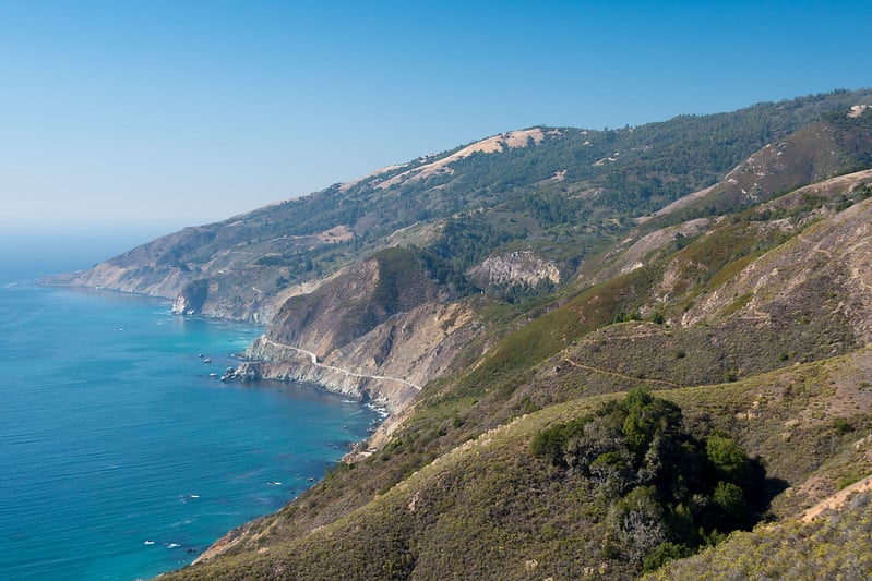
A trip along California’s iconic Hwy. 1 isn’t complete without an adventure through gorgeous Big Sur! The area is well known for nature — dramatic waves crashing against a rugged coastline, an array of flora and fauna, and miles and miles of some of the best hiking trails. There is so much to do in Big Sur, but you really can’t leave without completing at least one hike. If you’re unsure of where to go, I’ve got you covered! Whether you’re looking for a short or long hike, these Big Sur hiking trails offer scenic vistas, waterfalls, Redwoods, and more!
UPDATE: As of January 22, 2025, all of these trails and parks are open. Some may have limitations so check before you go. Also, expect delays when driving to Big Sur from Monterey/Carmel because of construction. Highway 1 is also closed to all traffic five miles south of Julia Pfeiffer Burns and between Esalen Institute and Lucia. At this time, there isn’t a reopening date set for that section of Highway 1.
This article contains affiliate links (paid links) and Veggies Abroad is a member of Amazon Services LLC Associated Program. At no cost to you, I may earn a small commission if you make a purchase — this helps keep Veggies Abroad churning out free content! For an explanation of our advertising partnerships, please review our privacy policy.
Don’t Miss These Big Sur Hiking Trails
These Big Sur hiking trails range from easy jaunts for the whole family to overnight excursions — something for every type of hiker! And, when you get hungry, be sure to check out the amazing lineup of vegan food in Monterey, Carmel, and Pacific Grove.
You might want to grab this hiking map before you go! It covers trails in Los Padres, Pfeiffer Big Sur State Park, Limekiln State Park, and more.
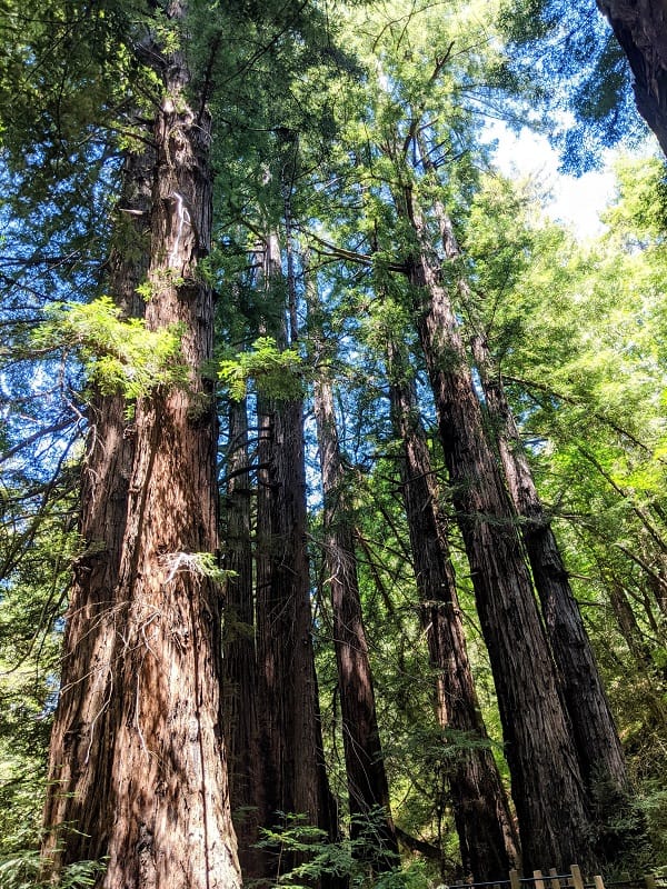
Pfeiffer Big Sur State Park
Pfeiffer Big Sur Rd, Big Sur, CA 93920
Looking for multiple hiking trails in Big Sur all at one spot? Then look no further than Pfeiffer Big Sur State Park! Nicknamed “mini-Yosemite,” this park has a little bit of everything to offer visitors — an array of beautiful scenery, sagacious redwoods, and a variety of wildlife (including bobcats! Don’t worry, it’s doubtful you’ll see one).
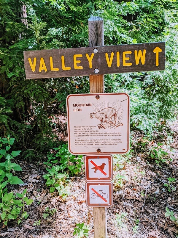
Depending on your hiking prowess, you have seven trail options ranging from .5 miles to 23 miles (one-way). Don’t miss the Valley View Trail, a moderate 2 mile out and back trail that meanders through a forest of conifers, oaks, and redwoods then ends with a scenic overlook of Big Sur River Valley Pt. Sur and Andrew Molera State Park.
Trails to Check Out at Pfeiffer Big Sur State Park
You might be interested in checking out two other trails, including Buzzard’s Roost and Pfeiffer Falls Trail. Buzzard’s Roost is a moderate to strenuous 3-mile climb through the redwoods to view the ocean. Pfeiffer Falls Trail re-opened in June 2021; It is shorter, just 1.3 miles out and back, and before its closure, it was very popular because it rewards hikers with a beautiful waterfall. The Pfeiffer Falls Trail connects with the Valley View Trail if you want to make the hike longer.
Finding the Pfeiffer Big Sur State Park is easy — it is well-marked, and there is plenty of parking. There is a $10 daily entrance fee for visitors, and if you want to stay overnight, camping is available.
Pfeiffer Big Sur State Park Hiking Highlights
Trails range from .5 mile to 23 miles — good options for the whole family.
Pine Ridge Trail
47555 CA-1, Big Sur, CA 93920 (Big Sur Station)
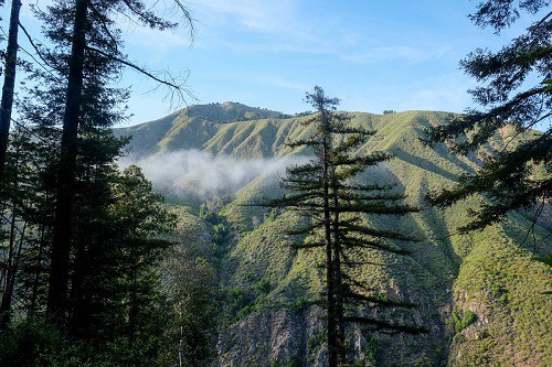
One of the most popular hiking trails in the Big Sur area, and for good reason! Aside from the gorgeous views, the most popular stop for hikers are the Sykes hot springs! Doesn’t that sound like the ultimate place to take a break after a grueling hike? I think so! Before you get really excited about soaking in the hot springs, please note this is a challenging trail even for experienced hikers due to the elevation changes. Most people split the hike up into two days to give themselves a break. The hike is 18 miles round-trip to the hot springs.
Where the Pine Ridge Trail Starts
The Pine Ridge Trail starts at The Big Sur Station, where you will need to pay a $10 fee to park, but no other permits are required. The first part of the trail will give your booty a workout—a 400m climb through a mix of Redwoods with beautiful mountain views. If you’re heading out on a nice summer day, plan to start early to avoid some of the heat.
The trail continues through a couple of campsites — Terrance Creek and Barlow Flat Camp. You can set up camp here or continue to Sykes Camps. Once you get past Barlow Flat Camp, be prepared for another booty-building climb up the side of the mountain, which is exposed to the California sun. Once you make it to the peak, you will descend into Sykes Camp. Once you finally arrive, the hot springs are just over a quarter mile from camp — follow the trail along the river and enjoy!
Pine Ridge Trail Highlights
Hot springs! It’s the only Big Sur trail where you can end the day with a relaxing soak.
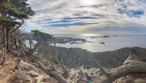
Cypress Grove Trail
62 CA-1, Carmel-By-The-Sea, CA 93923
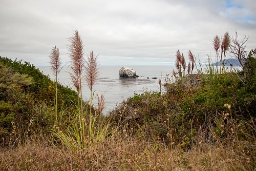
This trail is located in Point Lobos State Natural Preserve, one of the best state parks to visit in Monterey County. The Cypress Grove Trail is a short, easy, and relatively flat hike that’s only 0.8 miles. It loops around, so you start and end at the northwestern parking lot.
So, why hike this trail? For a couple of reasons.
What to See on The Cypress Grove Trail
First, fantastic flora — this is the spot to see one of the two remaining forests of Monterey cypress trees and beautiful coastal scenery. You’ll first start hiking through coastal scrub, then see the cypress trees growing along the cliffs with the Pacific Ocean in the background when you start the trail. Second, you might catch sea otters swimming around Headland Cove and California sea lions sitting on the cove rocks if you’re lucky.
If you visit in the spring, the trails are covered in beautiful wildflowers, but if you visit during the winter, you might catch a glimpse of migrating gray whales! With the unpredictable coastal weather, make sure to wear layers. I also suggest a long-sleeved shirt and pants because there is poison oak — you don’t want to end the hike itchy!
Cypress Grove Trail Highlights
This short hiking trail is part of the Point Lobos Park which is perfect for seeing whales, sea otters, and sea lions.
Lace Lichen Trail
62 CA-1, Carmel-By-The-Sea, CA 93923
The Lace Lichen Trail is another great hike in Point Lobos State Natural Preserve. This is an easy and flat hike that’s only 0.5 miles, and it starts near the park’s entrance and ends on Point Lobos Road; The trail runs parallel to that road. You can save on the entrance fees by parking outside the park and walking this trail. What’s so special about the Lace Lichen Trail?
What to See on The Lace Lichen Trail
While hiking this trail, you’ll see lace lichen hanging on the trees, making it a fantastic hike. Lace lichen is a green, lace-like plant that grows on the twigs and bark of trees. It’s essential for the trees since the lace lichen absorbs moisture from the fog, then the moisture accumulates as water droplets and drips down to the trees’ roots. While this is a short trail, the wet lace lichen hanging on the trees creates a unique ambiance to wander through.
Since this is the first of many trails, you’ll hike in Point Lobos, make sure to pack hiking essentials including reusable water bottles, snacks, and a flashlight if you’re staying until sunset.
Lace Lichen Trail Highlights
Short trail that features beautiful flora and fauna in Point Lobos.
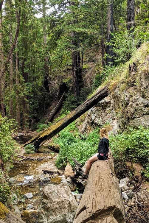
Vicente Flat Trail
CA-1, Big Sur, CA 93920
The Vincente Flat Trail is a 10-mile out and back trail. Its difficulty level is moderate to difficult due to the steep and narrow parts of the hike. Along this hike, expect to see stunning coastline views and a regrown forest of redwoods. The first few miles are the most scenic.
Where is The Vicente Flat Trail
The trail is located just two miles south of Limekiln State Park, and the trailhead is well marked. If coming from San Francisco, it will take 3.5 hours by car. To find the correct coordinates to this trailhead type in Kirk Creek Campgrounds into Google maps, the starting point for this hike will be just across the road. There is room to park along the side of the road for a few cars.
The first part of the hike is along a hillside with gorgeous ocean views, and in the spring, the area is covered in beautiful wildflowers. You do get a little break from the sun as the trail turns into the redwood groves of Hare Canyon.
Important Tips
- A lot of the hike is exposed to the sun, so wear a wide brimmed hat and sunscreen.
- Trekking poles and sturdy hiking shoes aren’t a bad idea, especially if you prefer added stability.
- There is a decent amount of poison oak — wear long pants.
- Expect the hike to take around 6 hours.
Hiking The Vincente Flat Trail can be done in a day or overnight. If you choose to camp, you have two options —Espinosa and Vincente Flat Campgrounds.
Vicente Flat Trail Highlights
Challenging 10-mile hike with scenic coastal views.
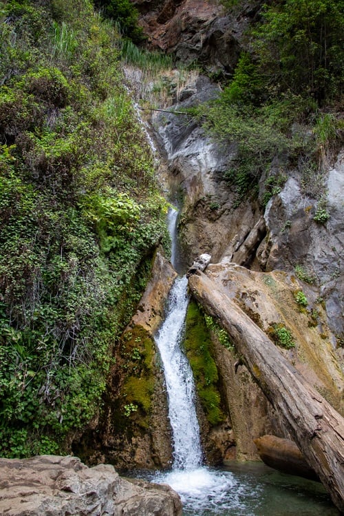
Limekiln Trail
63025 CA-1, Big Sur, CA 93920
If you are traveling through Big Sur on a road trip and are looking for a hike that’s got it all, look no further than Limekiln Trail. It’s also one of the best stops on the Pacific Coast Highway! Located in Limekiln State Park, this breathtaking hike takes you through towering redwoods and along a stunning creek.
What to See on The Limekiln Trail
There isn’t a single section of this hike that isn’t photogenic. The trail meanders through the shaded forest and crosses the river several times, offering beauty at every turn. You won’t know where to look next!
About halfway down the trail, you’ll take a quick detour off the main path and come to the majestic Limekiln Falls, a 100-foot stunner. Take a few minutes to enjoy this wonder before continuing.
The trail ends at the abandoned lime kilns, which the Rockland Lime and Lumber Company built in the late 1800s to purify the lime extracted from the area. Spend some time wandering around them, but leave them as you found them!
How to Get to The Limekiln Trail
Limekiln State Park is located right off Route 1, about 52 miles south of Carmel. You can park at the campground and pay the $10 day-use fee there, or if you have the California State Park Pass, you get in for free. Limekiln Creek Falls Trail is a 1.4-mile out-and-back trail that is suitable for reasonably fit people. There are parts where you may have to scramble under or over downed trees, and you will also have to cross the creek a few times over rocks and makeshift log bridges.
Limekiln Trail Highlights
100-foot waterfall + California history.
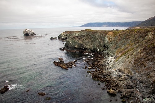
Jade Cove
69232 Cabrillo Hwy Big Sur, CA 93920
If you’re looking for a quick hike to stretch your legs after a long drive, stop at Jade Cove and Plaskett Rock Point. This easy 1.5-mile ocean-view trail combines a walk to Plaskett Rock and then meanders over to Jade Cove.
While this hike may not be the most scenic hike you’ve ever taken, it is very easy and would be doable for everyone, including kids. This makes it an excellent option for families who may need a break and want to eat some lunch.
The most technical part of the hike is at Jade Cove, where the adventurous can scramble down the bluff with the help of a rope to explore the rocky beach below. The cove got its name from the jade that was found there, and while you probably won’t find any today, it is still a fun area to explore.
Where is Jade Cove
Jade Cove and Plaskett Rock Point Trail are located in Los Padres National Forest, about 22 miles south of Julia Pfeiffer Burns State Park. There are two trailheads for this hike, and while they are unmarked, they aren’t too difficult to find. The easiest option is to head south from Plaskett Creek Campground approximately a quarter mile and look for parking on the west side of the road. The other trailhead is another quarter mile further and leads directly to Jade Cove.
Jade Cove Hike Highlights
Easy ocean view hike that’s great for kids.
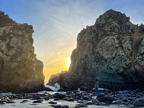
Pfeiffer Beach
9100 Sycamore Canyon Rd Big Sur, CA 93920
Tucked away on central California’s coastline, you can find the famous purple sand beach, Pfeiffer Beach. A must-visit location in the heart of Big Sur. Once you reach the entrance, there is a 2-mile drive down a narrow one-way dirt road. It is important to note that once the parking lot fills up at Pfeiffer Beach, the park rangers will turn you away. It is best to avoid the busiest time of day, which is between 12 pm to 2:30 pm.
Where to See The Purples Sand at Pfeiffer Beach
The hike to Pfeiffer Beach is a short and easy trail, approximately 0.2 miles, out and back. When you arrive at the beach, you are greeted with stunning views of the sandy beach and the Pacific Ocean. You will notice the swirls of violet-purple sand throughout the beach and the massive rock formations sprouting from the surface of the ocean.
Besides the unique purple sand, Pfeiffer Beach is also known for its Keyhole Arch. A large rock formation with a tunnel through the middle.
Enjoy your time at Pfeiffer Beach by taking a walk along the one-mile stretch of sandy beach, exploring the tidepools, or catching a beautiful California sunset. Pfeiffer Beach is also dog friendly, so it’s a great spot to bring your pup.
A visit to Pfeiffer Beach is a great way to unplug and explore all of California’s natural beauty.
Pfeiffer Beach Hike Highlights
A short hike to unique purple sand.
Packing Essentials for Big Sur Hikes
Whether going for a short jaunt or planning a multi-day hike, you shouldn’t leave home without these essential items!
- Hiking map that covers trails in Los Padres, Pfeiffer Big Sur State Park, Limekiln State Park, and more.
- A wide brimmed hat and sunscreen!
- If you’re going for multiple days, consider a water bottle with filtration
- Bug repellent —depending on the time of year, mosquitos can be terrible.
- Snacks! Go Marco bars are my favorite.
- A portable phone charger — since the reception is spotty, you might kill your battery much quicker than usual.
Where to Stay in Big Sur
Big Sur is a 90 mile stretch of Highway — providing a lengthy possibilities of places to stay! To get the most out of the area, I suggest choosing a couple places to stay, starting in the charming town of Carmel-By-The-Sea.
Where to Stay in Carmel-By-The Sea
7th Ave &, Casanova St, Carmel-By-The-Sea, CA 93921
Book Your StayWhere to Stay Near Pfeiffer Big Sur State Park
47225 CA-1, Big Sur, CA 93920
Book Your StayWhere to Stay in San Simeon
9415 Hearst Dr, San Simeon, CA 93452
Book Your StayBig Sur Hiking Wrap Up: More Vegan Travel Help
Now that you’re all set to explore and hike through Big Sur, you might be interested in checking out more vegan-friendly spots on the west coast! Don’t miss these great articles:
10 Spots for Vegan Food in San Francisco
Vegan Restaurant Guide to Seattle
Vegan Bakeries, Ice Cream, & Donuts in San Francisco
Complete Vegan Travel Guide to Los Angeles
13 Mouthwatering LA Vegan Bakeries
The Best Portland Vegan Travel Guide